Disclaimer: It is the responsibility of each rider to determine for themselves whether it is safe to visit the designated points. Due to varying factors such as the weather, the suitability of the motorcycle, the ability of a rider etc., Irish Photo Rally and its organisers cannot be held responsible for the safety and security of participants.
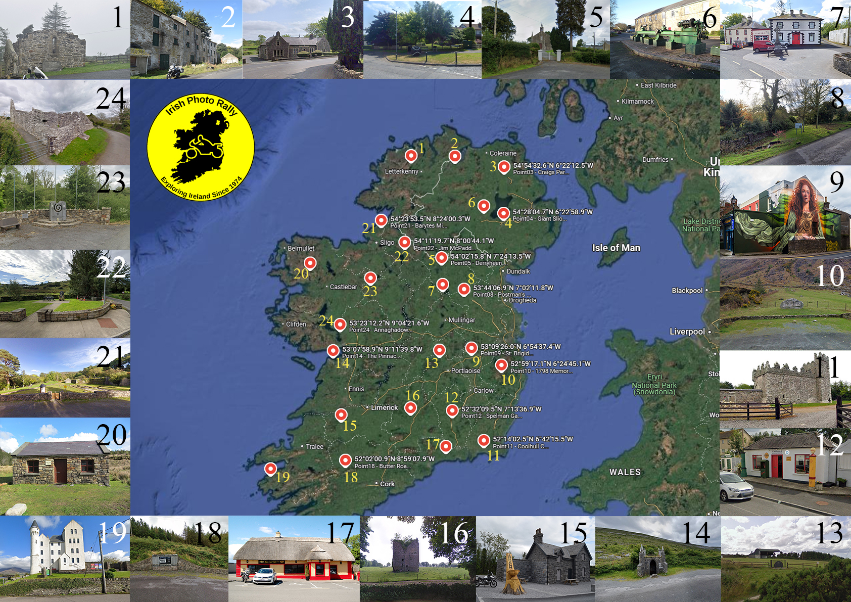
Photo Rally Points 2025
Download GPX file for 2025 here (including three extra points from the BMW Ulster Photo Rally): 2025.gpx
Download GPX file for 2025 here (including three extra points from the BMW Ulster Photo Rally): 2025.gpx
Google Maps
Scan the QR Code to open the IPR 2025 in Google Maps.
This has all the points and their names already entered for you, meaning you can select the point you want to travel to and get started without delay!
You can also click the link here: IPR 2025 – Google Maps

Point Information:
Number:1
Region: “Donegal”
Province: Ulster
Name: St Colmcille’s Abbey
10km W of Kilmacrennan.
Coordinates:
Irish Grid : IC 05873 18699
Degrees Minutes Seconds: N55 00’ 56″ W7 54’ 32″
Region: “Donegal”
Province: Ulster
Name: St Colmcille’s Abbey
10km W of Kilmacrennan.
Coordinates:
Irish Grid : IC 05873 18699
Degrees Minutes Seconds: N55 00’ 56″ W7 54’ 32″
Number:2
Region: “Derry”
Province: Ulster
Name: Edenreagh Old Mill
2 Km S of Eglinton
Coordinates:
Irish Grid : IC 52417 1871
Degrees Minutes Seconds: N55 00’ 47″ W7 10’ 53″
Region: “Derry”
Province: Ulster
Name: Edenreagh Old Mill
2 Km S of Eglinton
Coordinates:
Irish Grid : IC 52417 1871
Degrees Minutes Seconds: N55 00’ 47″ W7 10’ 53″
Number:3
Region: “Antrim”
Province: Ulster
Name: Craigs Parochial School
8km NW of Ballymena
Coordinates:
Irish Grid : ID 04588 08042
Degrees Minutes Seconds : N54 54’ 33″ W6 22’ 12″
Region: “Antrim”
Province: Ulster
Name: Craigs Parochial School
8km NW of Ballymena
Coordinates:
Irish Grid : ID 04588 08042
Degrees Minutes Seconds : N54 54’ 33″ W6 22’ 12″
Number:4
Region: “Down/Armagh”
Province: Ulster
Name: Giant Sliotar
3km W of Lurgan
Coordinates:
Irish Grid : IJ 04891 58928
Degrees Minutes Seconds : N54 28’ 05″ W6 22’ 59″
Region: “Down/Armagh”
Province: Ulster
Name: Giant Sliotar
3km W of Lurgan
Coordinates:
Irish Grid : IJ 04891 58928
Degrees Minutes Seconds : N54 28’ 05″ W6 22’ 59″
Number:5
Region: “Cavan/Monaghan”
Province: Ulster
Name: Derryheen Church of Ireland
2km W of Butlersbridge
Coordinates:
Irish Grid : IH 39117 09994
Degrees Minutes Seconds : N54 02’ 16″ W7 24’ 13″
Region: “Cavan/Monaghan”
Province: Ulster
Name: Derryheen Church of Ireland
2km W of Butlersbridge
Coordinates:
Irish Grid : IH 39117 09994
Degrees Minutes Seconds : N54 02’ 16″ W7 24’ 13″
Number:6
Region: “Fermanagh/Tyrone”
Province: Ulster
Name: The Big Lathe
Coalisland
Coordinates:
Irish Grid : IH 83780 662870
Degrees Minutes Seconds: N54 32’ 17″ W6 42’ 23″
Region: “Fermanagh/Tyrone”
Province: Ulster
Name: The Big Lathe
Coalisland
Coordinates:
Irish Grid : IH 83780 662870
Degrees Minutes Seconds: N54 32’ 17″ W6 42’ 23″
Number:7
Region: “Longford/Westmeath”
Province: Leinster
Name: Myles “The Slasher” O’Reilly
Finnea
Coordinates:
Irish Grid : IN 40334 81324
Degrees Minutes Seconds: N53 46’ 48″ W7 23’ 20″
Region: “Longford/Westmeath”
Province: Leinster
Name: Myles “The Slasher” O’Reilly
Finnea
Coordinates:
Irish Grid : IN 40334 81324
Degrees Minutes Seconds: N53 46’ 48″ W7 23’ 20″
Number:8
Region: “Louth/Meath”
Province: Leinster
Name: Postman’s Hut
10km west of Kells
Coordinates:
Irish Grid : IN 63627 76594
Degrees Minutes Seconds: N53 44′ 07″ W7 02′ 12″
Region: “Louth/Meath”
Province: Leinster
Name: Postman’s Hut
10km west of Kells
Coordinates:
Irish Grid : IN 63627 76594
Degrees Minutes Seconds: N53 44′ 07″ W7 02′ 12″
Number:9
Region: “Dublin/Kildare”
Province: Leinster
Name: St Brigid Mural
Kildare Town
Coordinates:
Irish Grid : IN 72940 12383
Degrees Minutes Seconds: N53 09’ 26″ W6 54’ 37″
Region: “Dublin/Kildare”
Province: Leinster
Name: St Brigid Mural
Kildare Town
Coordinates:
Irish Grid : IN 72940 12383
Degrees Minutes Seconds: N53 09’ 26″ W6 54’ 37″
Number:10
Region: “Wicklow”
Province: Leinster
Name: 1798 Rock
8km W of Laragh
Coordinates:
Irish Grid : IT 06660 94185
Degrees Minutes Seconds: N52 59’ 17″ W6 24’ 45″
Region: “Wicklow”
Province: Leinster
Name: 1798 Rock
8km W of Laragh
Coordinates:
Irish Grid : IT 06660 94185
Degrees Minutes Seconds: N52 59’ 17″ W6 24’ 45″
Number:11
Region: “Wexford”
Province: Leinster
Name: Coolhull Castle
3.5km W of Duncormick
Coordinates:
Irish Grid : IS 88574 09882
Degrees Minutes Seconds: N52 14’ 02″ W6 42’ 15″
Region: “Wexford”
Province: Leinster
Name: Coolhull Castle
3.5km W of Duncormick
Coordinates:
Irish Grid : IS 88574 09882
Degrees Minutes Seconds: N52 14’ 02″ W6 42’ 15″
Number:12
Region: “Carlow/Kilkenny”
Province: Leinster
Name: Spelman’s Garage
Stoneyford
Coordinates: Irish Grid : IS 52511 42970
Degrees Minutes Seconds: N52 32’ 09″ W7 13’ 37′
Region: “Carlow/Kilkenny”
Province: Leinster
Name: Spelman’s Garage
Stoneyford
Coordinates: Irish Grid : IS 52511 42970
Degrees Minutes Seconds: N52 32’ 09″ W7 13’ 37′
Number:13
Region: “Laois/Offaly”
Province: Leinster
Name: Festival Field
8km WNW of Mountmellick
Coordinates:
Irish Grid : IN 37374 09348
Degrees Minutes Seconds: N53 08’ 01″ W7 26’ 32″
Region: “Laois/Offaly”
Province: Leinster
Name: Festival Field
8km WNW of Mountmellick
Coordinates:
Irish Grid : IN 37374 09348
Degrees Minutes Seconds: N53 08’ 01″ W7 26’ 32″
Number:14
Region: “Clare”
Province: Munster
Name: The Pinnacle Well
3km NW of Ballyvaughan
Coordinates:
Irish Grid : IM 20108 09801
Degrees Minutes Seconds: N53 07’ 59″ W9 11’ 40″
Region: “Clare”
Province: Munster
Name: The Pinnacle Well
3km NW of Ballyvaughan
Coordinates:
Irish Grid : IM 20108 09801
Degrees Minutes Seconds: N53 07’ 59″ W9 11’ 40″
Number:15
Region: “Limerick”
Province: Munster
Name: Ardagh train station
5km NW of Newcastle West
Coordinates:
Irish Grid : IR 28408 38509
Degrees Minutes Seconds: N52 29’ 37″ W9 03’ 17″
Region: “Limerick”
Province: Munster
Name: Ardagh train station
5km NW of Newcastle West
Coordinates:
Irish Grid : IR 28408 38509
Degrees Minutes Seconds: N52 29’ 37″ W9 03’ 17″
Number:16
Region: “Tipperary”
Province: Munster
Name: Ardmayle Castle
5.5km NNW of Cashel
Coordinates:
Irish Grid : IS 05700 45850
Degrees Minutes Seconds: N52 33’ 52″ W7 55’ 00″
Region: “Tipperary”
Province: Munster
Name: Ardmayle Castle
5.5km NNW of Cashel
Coordinates:
Irish Grid : IS 05700 45850
Degrees Minutes Seconds: N52 33’ 52″ W7 55’ 00″
Number:17
Region: “Waterford”
Province: Munster
Name: Dunphy’s pub
5km NE of Bunmahon
Coordinates:
Irish Grid : IS 45520 02920
Degrees Minutes Seconds: N52 10’ 36″ W7 20’ 07”
Region: “Waterford”
Province: Munster
Name: Dunphy’s pub
5km NE of Bunmahon
Coordinates:
Irish Grid : IS 45520 02920
Degrees Minutes Seconds: N52 10’ 36″ W7 20’ 07”
Number:18
Region: “Cork”
Province: Munster
Name: Butter Road plaque
6km SE of Millstreet
Coordinates:
Irish Grid : IW 32415 87244
Degrees Minutes Seconds: N52 02’ 01″ W8 59’ 08″
Region: “Cork”
Province: Munster
Name: Butter Road plaque
6km SE of Millstreet
Coordinates:
Irish Grid : IW 32415 87244
Degrees Minutes Seconds: N52 02’ 01″ W8 59’ 08″
Number:19
Region: “Kerry”
Province: Munster
Name: The Old Barracks
Caherciveen
Coordinates:
Irish Grid : IV 47115 79752
Degrees Minutes Seconds: N51 56’ 58″ W10 13’ 28″
Region: “Kerry”
Province: Munster
Name: The Old Barracks
Caherciveen
Coordinates:
Irish Grid : IV 47115 79752
Degrees Minutes Seconds: N51 56’ 58″ W10 13’ 28″
Number:20
Region: “Mayo”
Province: Connacht
Name: Brogan Carroll Bothy
12km N of Newport
Coordinates:
Irish Grid : IF 96886 05586
Degrees Minutes Seconds : N53 59’ 21″ W9 34’ 22″
Region: “Mayo”
Province: Connacht
Name: Brogan Carroll Bothy
12km N of Newport
Coordinates:
Irish Grid : IF 96886 05586
Degrees Minutes Seconds : N53 59’ 21″ W9 34’ 22″
Number:21
Region: “Sligo”
Province: Connacht
Name: Barytes Mill
15km NNW of Sligo
Coordinates:
Irish Grid : IG 74064 50028
Degrees Minutes Seconds: N54 23’ 53″ W8 24’ 00″
Region: “Sligo”
Province: Connacht
Name: Barytes Mill
15km NNW of Sligo
Coordinates:
Irish Grid : IG 74064 50028
Degrees Minutes Seconds: N54 23’ 53″ W8 24’ 00″
Number:22
Region: “Leitrim”
Province: Connacht
Name: Jim McPadden Memorial
Dowra
Coordinates:
Irish Grid : IG 99250 26647
Degrees Minutes Seconds: N54 11’ 20″ W8 00’ 44″
Region: “Leitrim”
Province: Connacht
Name: Jim McPadden Memorial
Dowra
Coordinates:
Irish Grid : IG 99250 26647
Degrees Minutes Seconds: N54 11’ 20″ W8 00’ 44″
Number:23
Region: “Roscommon”
Province: Connacht
Name: Byrne & Morley
7km S of Ballaghaderreen
Coordinates:
Irish Grid : IM 62202 88161
Degrees Minutes Seconds: N53 50’ 30″ W8 34’ 30″
Region: “Roscommon”
Province: Connacht
Name: Byrne & Morley
7km S of Ballaghaderreen
Coordinates:
Irish Grid : IM 62202 88161
Degrees Minutes Seconds: N53 50’ 30″ W8 34’ 30″
Number:24
Region: “Galway”
Province: Connacht
Name: Annaghadown Priory
10km SSE of Headford
Coordinates:
Irish Grid : IM 28678 37908
Degrees Minutes Seconds: N53 23’ 12″ W9 04’ 22″
Region: “Galway”
Province: Connacht
Name: Annaghadown Priory
10km SSE of Headford
Coordinates:
Irish Grid : IM 28678 37908
Degrees Minutes Seconds: N53 23’ 12″ W9 04’ 22″
Previous Photo Rally GPX Files
Below we have made available the GPX files for each year from 2003 – 2024.
Click the links below for the year you require to download the GPX File.