Disclaimer: It is the responsibility of each rider to determine for themselves whether it is safe to visit the designated points. Due to varying factors such as the weather, the suitability of the motorcycle, the ability of a rider etc., Irish Photo Rally and its organisers cannot be held responsible for the safety and security of participants.
Google Maps
Scan the QR Code to open the IPR 2026 in Google Maps.
This has all the points and their names already entered for you, meaning you can select the point you want to travel to and get started without delay
You can also click the link here to open the Google Map with Pre-Loaded Points: IPR 2026 – Google Maps
Note: When you open the map on Google Maps, you can now click on any point and use the ‘more info’ to see the photo of the point selected. Like this

Point Information:
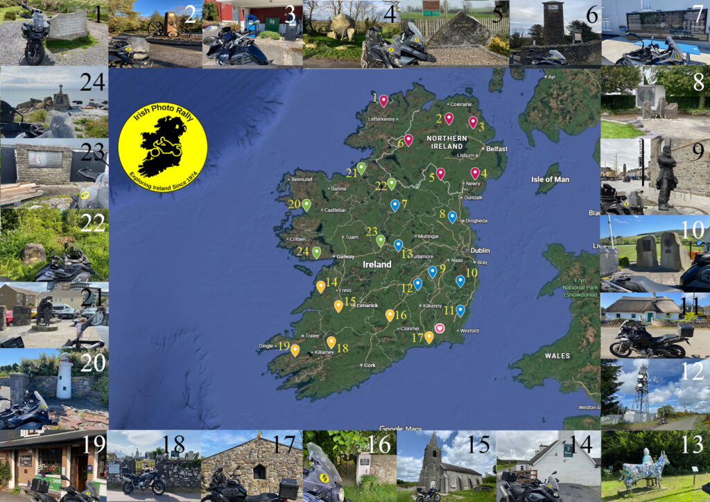
Number:1
Region: “Donegal”
Province: Ulster
Name: Droichead na nDeor
7km NW of Glenveigh
Coordinates:
Irish Grid : IB 99300 26800
Decimal Degrees: N55.08848° W8.01175°
Region: “Donegal”
Province: Ulster
Name: Droichead na nDeor
7km NW of Glenveigh
Coordinates:
Irish Grid : IB 99300 26800
Decimal Degrees: N55.08848° W8.01175°
Number:2
Region: “Derry”
Province: Ulster
Name: Linen Memorial
4km NE of Maghera
Coordinates:
Irish Grid : IC 87271 04320
Decimal Degrees: N54.87895° W6.64116°
Region: “Derry”
Province: Ulster
Name: Linen Memorial
4km NE of Maghera
Coordinates:
Irish Grid : IC 87271 04320
Decimal Degrees: N54.87895° W6.64116°
Number:3
Region: “Antrim”
Province: Ulster
Name: Petrol pumps
10km SE of Ballymena
Coordinates:
Irish Grid : IJ 19491 99441
Decimal Degrees: N54.82850° W6.14146°
Region: “Antrim”
Province: Ulster
Name: Petrol pumps
10km SE of Ballymena
Coordinates:
Irish Grid : IJ 19491 99441
Decimal Degrees: N54.82850° W6.14146°
Number:4
Region: “Down/Armagh”
Province: Ulster
Name: Goward Dolmen
4km NE of Hilltown
Coordinates:
Irish Grid : IJ 24377 31018
Decimal Degrees: NN54.21300° W6.09431°
Region: “Down/Armagh”
Province: Ulster
Name: Goward Dolmen
4km NE of Hilltown
Coordinates:
Irish Grid : IJ 24377 31018
Decimal Degrees: NN54.21300° W6.09431°
Number:5
Region: “Cavan/Monaghan”
Province: Ulster
Name: Clontibret Memorial
1km east of Clontibret
Coordinates:
Irish Grid : IH 76950 29330
Decimal Degrees: N54.20714° W6.82148°
Region: “Cavan/Monaghan”
Province: Ulster
Name: Clontibret Memorial
1km east of Clontibret
Coordinates:
Irish Grid : IH 76950 29330
Decimal Degrees: N54.20714° W6.82148°
Number:6
Region: “Fermanagh/Tyrone”
Province: Ulster
Name: Drumquin Clock
12km W of Omagh
Coordinates:
Irish Grid : IH 32979 74334
Decimal Degrees: N54.61612° W7.49032°
Region: “Fermanagh/Tyrone”
Province: Ulster
Name: Drumquin Clock
12km W of Omagh
Coordinates:
Irish Grid : IH 32979 74334
Decimal Degrees: N54.61612° W7.49032°
Number:7
Region: “Longford/Westmeath”
Province: Leinster
Name: Land War Memorial
Drumlish
Coordinates:
Irish Grid : IN 15253 85629
Decimal Degrees: N53.82008° W7.76917°
Region: “Longford/Westmeath”
Province: Leinster
Name: Land War Memorial
Drumlish
Coordinates:
Irish Grid : IN 15253 85629
Decimal Degrees: N53.82008° W7.76917°
Number:8
Region: “Louth/Meath”
Province: Leinster
Name: Five Girls Memorial
4km SSW of Slane
Coordinates:
Irish Grid : IN 94459 70175
Decimal Degrees: N53.67294° W6.57150°
Region: “Louth/Meath”
Province: Leinster
Name: Five Girls Memorial
4km SSW of Slane
Coordinates:
Irish Grid : IN 94459 70175
Decimal Degrees: N53.67294° W6.57150°
Number:9
Region: “Dublin/Kildare”
Province: Leinster
Name: Ernest Shackleton Statue
Athy
Coordinates:
Irish Grid : IS 68318 93888
Decimal Degrees: N52.99168° W6.98339°
Region: “Dublin/Kildare”
Province: Leinster
Name: Ernest Shackleton Statue
Athy
Coordinates:
Irish Grid : IS 68318 93888
Decimal Degrees: N52.99168° W6.98339°
Number:10
Region: “Wicklow”
Province: Leinster
Name: Billy Byrne Memorial
6km WNW of Aughrim
Coordinates:
Irish Grid : IT 07028 81251
Decimal Degrees: N52.87184° W6.41130°
Region: “Wicklow”
Province: Leinster
Name: Billy Byrne Memorial
6km WNW of Aughrim
Coordinates:
Irish Grid : IT 07028 81251
Decimal Degrees: N52.87184° W6.41130°
Number:11
Region: “Wexford”
Province: Leinster
Name: House of Stories
11km E of Enniscorthy
Coordinates:
Irish Grid : IT 08465 39853
Decimal Degrees: N52.49971° W6.40359°
Region: “Wexford”
Province: Leinster
Name: House of Stories
11km E of Enniscorthy
Coordinates:
Irish Grid : IT 08465 39853
Decimal Degrees: N52.49971° W6.40359°
Number:12
Region: “Carlow/Kilkenny”
Province: Leinster
Name: Ballyoskill Mast
6km NE of Ballyragget
Coordinates:
Irish Grid : IS 47529 76196
Decimal Degrees: N52.83496° W7.29552°
Region: “Carlow/Kilkenny”
Province: Leinster
Name: Ballyoskill Mast
6km NE of Ballyragget
Coordinates:
Irish Grid : IS 47529 76196
Decimal Degrees: N52.83496° W7.29552°
Number:13
Region: “Laois/Offaly”
Province: Leinster
Name: St Manchan’s Cow
Ballycumber
Coordinates:
Irish Grid : IN 20110 30465
Decimal Degrees: N53.32430° W7.69897°
Region: “Laois/Offaly”
Province: Leinster
Name: St Manchan’s Cow
Ballycumber
Coordinates:
Irish Grid : IN 20110 30465
Decimal Degrees: N53.32430° W7.69897°
Number:14
Region: “Clare”
Province: Munster
Name: McCarthy’s Bar
14km S of Lahinch
Coordinates:
Irish Grid : IR 10872 73356
Decimal Degrees: N52.80417° W9.32231°
Region: “Clare”
Province: Munster
Name: McCarthy’s Bar
14km S of Lahinch
Coordinates:
Irish Grid : IR 10872 73356
Decimal Degrees: N52.80417° W9.32231°
Number:15
Region: “Limerick”
Province: Munster
Name: Nantenan Church
4km N of Rathkeale
Coordinates:
Irish Grid : IR 35419 45842
Decimal Degrees: N52.56046° W8.95300°
Region: “Limerick”
Province: Munster
Name: Nantenan Church
4km N of Rathkeale
Coordinates:
Irish Grid : IR 35419 45842
Decimal Degrees: N52.56046° W8.95300°
Number:16
Region: “Tipperary”
Province: Munster
Name: : Lena Rice
New Inn
Coordinates:
Irish Grid : IS 08151 32047
Decimal Degrees: N52.44027° W7.88088°
Region: “Tipperary”
Province: Munster
Name: : Lena Rice
New Inn
Coordinates:
Irish Grid : IS 08151 32047
Decimal Degrees: N52.44027° W7.88088°
Number:17
Region: “Waterford”
Province: Munster
Name: Land League
6km E of Tramore
Coordinates:
Irish Grid : IS 64253 01441
Decimal Degrees: N52.16156° W7.06181°
Region: “Waterford”
Province: Munster
Name: Land League
6km E of Tramore
Coordinates:
Irish Grid : IS 64253 01441
Decimal Degrees: N52.16156° W7.06181°
Number:18
Region: “Cork”
Province: Munster
Name:Kilcorney Cemetery
5km NE of Millstreet
Coordinates:
Irish Grid : IW 38334 81682
Decimal Degrees: N52.07654° W8.97426°
Region: “Cork”
Province: Munster
Name:Kilcorney Cemetery
5km NE of Millstreet
Coordinates:
Irish Grid : IW 38334 81682
Decimal Degrees: N52.07654° W8.97426°
Number:19
Region: “Kerry”
Province: Munster
Name:The Climber’s Inn
14km SW of Killorglin
Coordinates:
Irish Grid : IV 72447 84068
Decimal Degrees: N51.99451° W9.85776°
Region: “Kerry”
Province: Munster
Name:The Climber’s Inn
14km SW of Killorglin
Coordinates:
Irish Grid : IV 72447 84068
Decimal Degrees: N51.99451° W9.85776°
Number:20
Region: “Mayo”
Province: Connacht
Name: Rosmoney Model Lighthouse
7km NW of Westport
Coordinates:
Irish Grid : IL 93306 87460
Decimal Degrees: N53.82580° W9.62103°
Region: “Mayo”
Province: Connacht
Name: Rosmoney Model Lighthouse
7km NW of Westport
Coordinates:
Irish Grid : IL 93306 87460
Decimal Degrees: N53.82580° W9.62103°
Number:21
Region: “Sligo”
Province: Connacht
Name: Famine Memorial
Sligo
Coordinates:
Irish Grid : IG 69000 36221
Decimal Degrees: N54.27387° W8.47662°
Region: “Sligo”
Province: Connacht
Name: Famine Memorial
Sligo
Coordinates:
Irish Grid : IG 69000 36221
Decimal Degrees: N54.27387° W8.47662°
Number:22
Region: “Leitrim”
Province: Connacht
Name: Site of Dernasmallan Church
4km NW of Ballinamore
Coordinates:
Irish Grid : IH 10585 14804
Decimal Degrees: N54.08230° W7.83905°
Region: “Leitrim”
Province: Connacht
Name: Site of Dernasmallan Church
4km NW of Ballinamore
Coordinates:
Irish Grid : IH 10585 14804
Decimal Degrees: N54.08230° W7.83905°
Number:23
Region: “Roscommon”
Province: Connacht
Name: Sean O’Neachtain
10km SW of Athlone
Coordinates:
Irish Grid : IM 95299 36502
Decimal Degrees: N53.37889° W8.07139°
Region: “Roscommon”
Province: Connacht
Name: Sean O’Neachtain
10km SW of Athlone
Coordinates:
Irish Grid : IM 95299 36502
Decimal Degrees: N53.37889° W8.07139°
Number:24
Region: “Galway”
Province: Connacht
Name: 1917 Mine Memorial
7km W of Spiddle
Coordinates:
Irish Grid : IM 06368 21301
Decimal Degrees: N53.23408° W9.40296°
Region: “Galway”
Province: Connacht
Name: 1917 Mine Memorial
7km W of Spiddle
Coordinates:
Irish Grid : IM 06368 21301
Decimal Degrees: N53.23408° W9.40296°
Previous Photo Rally GPX Files
Below we have made available the GPX files for each year from 2003 – Present.
Click the links below for the year you require to download the GPX File.